 I guess we all new it was just a matter of time before we would be affected by wildfires. For the last few years they are been all around us.
2003 Wildfires
Okanagan Mountain Park Fire which was a major event in BC’s history.
This fire was 25,600 hectares and affected the communities of Kelowna and Naramata. Over 33,00o people were evacuated and 238 homes were damaged or lost in this fire.
The fire damaged and burned trestles along the famous Kettle Valley Railway.
The McLure Fire also happened that year with a devastating loss and damage of 72 homes and a few businesses as well. 3800 people were evacuated and the fire burned 26,420 hectares.
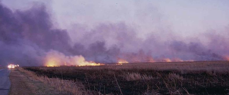
2009 Wildfires
Lava Canyon, was the largest fire in the Chilcotin, that year at 66,719 hectare (667 square kilometres), and led to evacuation orders and alerts. That is nothing to the fires of 2017.
Kelly Creek Wildfire in Edgehills Provincial Park, which is 20 km southwest of Clinton, took 20,925 hectares two structures were lost in that fire.
2010 Wildfires
Pelican Lake fire which was north of Nazko, was 35,506 hectares . These blazes caused evacuation orders and alerts.
Binta Lake Wildfire, which is south of Burns Lake, went from 7,000 hectares to 35,000 hectares in 12-hours. It grew so quickly because of the dry conditions and winds. Much like we are experiencing in 2017.
In the end it burned about 40,000 hectares and was the largest fire in 2010. The Chilcoltin fires of 2017 have surpassed that and are still burning as I am writing.
Meldrum Creek complex of fires covered an area of 47,293 hectares, there were numerous evacuation orders and alerts due to this fire.
Bull Canyon complex of fires near Alexis Creek covered a combined area of 35,000 hectares. This fire caused evacuation and alerts, but this year 2017 the Lee’s Corner Store was burned down. A place I hold dear as we stopped there often on the trip to my Uncles ranch out in the Chilcotin.
2014 Wildfires
This year was the third worst season in record for BC since 1950.
Chelaslie River Wildfire, 133,098 hectares burned 7 kilometres south of the Chelaslie River, this included sections of Entiako Provincal Park. There were several evacuation alerts and orders due to this fire.
Tenakihi-Mesilinka Complex 64,576 hectares in size this fire was located 50 kilometres west of Williston Lake, located between the Mesilinka River and Tenakihi Creek.
Forres Mountain Wildfire 50 kilometres northwest of Williston Lake, it burned 29,672 hectares and resulted in an evacuation alert.
Red Deer Creek Wildfire this fire started 61 kilometres southeast of Tumbler Ridge and ended up burning into Alberta. It ended up being 33,547 hectares and led to an evacuation order.
Mount McAllister Wildfire 56 kilometres west of Chetwynd burned 26,273 hectares and led to the evacuation of Hudson’s Hope.
2017 Here we are today
A great portion of BC remains under a state of emergency as many wildfires engulf the province. New fires are starting daily as the dry conditions continue. 15 fires are threatening communities and over 44,000 people have been evacuated.
The Ashcoft Fire which is known as the Elephant Hill fire has grown to about 61,500 hectares and many evacuations orders are in effect.
Some structures have been lost in this fire but we do not know how many as of this writing.
The Gustafsen North Forest Service Road, west of 100 Mile House.
This fire is estimated at about 5700 hectares and 100 percent contained.
Everyone has been able to return to the 100 Mile area, but are still on evacuation alert as thing could change on a moments notice.
Tautri Complex
This fire is burning just north of Rosita-Meldrum Forest Service Road, and is approximately 80 kilometres northwest of Williams Lake, it is approximately 51,113 hectares in size.
Kleena Kleene Complex
This fire is burning west of Highway 20, mainly along the Klinaklini Riverand is about 200 kilometres west of Williams Lake, it is estimated to be 5,318 hectares at this time.
Chezacut Complex
This fire is located about 140 kilometres northwest of Williams Lake. It is estimated to be about 10,194 hectares in size, but is now only estimated to be 25 per cent contained.
Evacuation orders are in place due to this fire, a map can be found here.
Hanceville Riske Creek
This fire is the largest but maybe not the most notable because of where it is located. This fire has burned 132,200 hectares and is the largest burning fire in BC at this time.
I went onto BC Fire info centre page and totalled the wildfires burning right now.
It’s scary – the total is 283,096.42 hectares of forest burning as of this writing and our forest fire season has just began.
Our property had been on evacuation order and is now on evacuation alert. We purchased this property last year and cut most of our firewood from it this last fall.
The forest is full of dead trees due to the pine beetle epidemic. Some parts you can’t even walk in due to the amount of trees that have died and fallen to the forest floor.
There is a lot of forest in BC in this same condition so it is no wonder why we are having these big fires, there is so much fuel on the forest floor to keep them going.
We were on holidays and came back and found we were unable to fly back home due to the fires. Our vehicle was and still is sitting at the airport 60 km from out home town.
We live in a rural area, with no public transportation so not having a vehicle can be challenging in itself.
We will manage and I hear that the town close to were the airport is will be opening up any day now, so long the weather holds out and there are no new fires.
The firefighters are doing an amazing job, we have firefighters from all over the country here battling these fires as well as from other countries. We are so fortunate to have all this help.
I’m am hoping this is the last of the fires and we can all get back to some kind of normal life.

© 2017 – 2026, Teresa. All rights reserved.